
|
With advances in digital technology, it's becoming increasingly practical to provide virtually any sensor with a wired or wireless connection that enables remote access to the devices' control inputs and data outputs. Through a variety of location technologies (e.g., GPS, Cell-ID, and Cell-ID with triangulation), both fixed and mobile sensing devices can report their geographic location along with the data they have collected.
If these connections can be layered with Internet and Web protocols, then text schemas conforming to the Web's eXtensible Markup Language (XML) can be used to publish formal descriptions of a sensor's capabilities, location, and service interfaces. Today's Web brokers, clients, and servers can parse and interpret XML-based sensor descriptions, enabling automated discovery of Web-based sensors, as well as initiating the processing and geolocation of their observations. By publishing XML descriptions of its control interface, a sensor can enable direct communications that will let you receive real-time or stored observation data, determine the sensor's location and orientation, identify the characteristics of its observation capabilities, and even submit requests for specific observation tasks.
SensorML and Sensor Web Enablement
As part of its effort to enable access to Web-resident devices, OGC is creating and testing a framework to maximize the discoverability and interoperability of sensor systems through standard Web-based services. Currently, the framework defines catalog services for discovering sensors and sensor data; collection services for accessing real-time or archived observation data; planning services for tasking sensors; and notification services for providing users the results of task requests or for alerting users of other services of observed phenomena of interest. Additionally, the framework includes standard ways of encoding observation and measurement schema and for describing the geometric, dynamic, and observational characteristics of sensors of all kinds (SensorML).
SensorML provides a functional model supporting the processing and geolocation of sensor observations, rather than a detailed description of sensor hardware. SensorML provides support for in situ and remote sensors, on both static and dynamic platforms (see Figure 1).
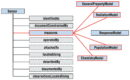 Figure 1. SensorML provides a complete description of an instrument's capabilities and gives the information needed to process and geolocate the measured data. The information includes the sensor name, type, and identification numbers (identifiedAs); temporal, legal, or classification constraints of the description (documentConstrainedBy); a reference to the platform description (attachedTo); the sensor's coordinate reference system definition (hasCRS); the sensor's location (locatedUsing); the response characteristics and information for geolocating samples (measures); the sensor operator and tasking services (operatedBy); textual metadata and history of the sensor (describedBy); and textual metadata and history of the sensor description document itself (documentedBy). |
|
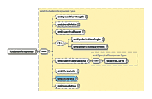
For geolocation of observations, SensorML supports rigorous models for in situ sensors, scanners, profilers, and optical cameras, as well as function-based models, such as the Rapid Positioning Coordinates model used extensively by national mapping agencies. SensorML also supports an extensible collection of properties for describing the sensor's response characteristics and quality of measurement. Thus, the markup language is applicable to virtually any sensor type, whether it's measuring temperature, water quality, voltage, location, chemical concentration, or radiation (see Figure 2).
Applications
Online catalogs of XML-based metadata for online sensors and data repositories constitute a revolution in the discovery and assessment of live data sources and archived data produced by sensors. Just as the Web is based on fairly simple standards, the sensor Web enablement framework is not particularly complicated. By describing sensors using SensorML, anyone can put sensors or sensor data online for others to find and use.
|
Adherence to a common schema makes it possible to search for sensors and sensor data with more precision than is available with text searches using a search engine. For example, searching for particular kinds of sensors and data in a particular geographic region, with data collected within a particular time window, will be easy. This has significance for science, environmental monitoring, transportation management, public safety, disaster management, utilities operations, industrial controls, facilities management, and many other activities.
In addition, because the metadata will be machine readable, SensorML will enable development of software tools that automatically coregister, or fuse, different kinds of data with little human intervention. Data sets will be automatically usable with geoÇrocessing software (e.g., GIS), remote sensing packages, and online service components that provide additional functionality (e.g., image processing, statistical analysis, and pattern recognition).
SensorML concepts have already proven useful for such applications as coincident search for relevant data, on-demand processing and geolocation of real-time data, premission planning, and visual fusion of disparate data from multiple sensors. SensorML ûill also play a role in helping sensors become more intelligent and autonomous by assisting in onboard processing of data and communications among multiple sensors. Instead of serving as passive eyes with little understanding of what they're observing, sensors will not only be capable of understanding what they're observing but also where they're looking.
In particular, as webs of SensorML-enabled intelligent sensors become more common, users in remote locations will be able to access and use real-time sensor data directly from the sensor, with no need for intermediate, time-consuming processing at a centýal data processing center. In addition, intelligent sensors will be able to better recognize phenomena of interest and to alert users or other sensors to the existence and location of these events. Sensors receiving alerts can choose or be tasked to respond to these notices by maneuvering to or pointing at the location or by changing scanning or sensitivity parameters to better observe the feature of interest.
|
Conclusions
SensorML and sensor Web enablement activities are a major milestone in the advancement of sensor applications. Because OGC is the world's authoritative source for standards related to geoprocessing interoperability, and because xOGC has strong international industry and government support in domains that depend on sensors, it's likely that SensorML will quickly become established in all areas where such a standard can be of use.
Editor's Note
OGC is an international industry consortium of more than 230 companies, government agencies, and universities participating in a consensus process to develop publicly available geoprocessing specifications. Additional information can be found at www.opengis.org.
The SensorML schema is described in the OGC Interoperability Program Report, OGC IPR 026, edited by Mike Botts and coauthored by Ron Lake of Galdos, Inc. (Canada), and Simon Cox of CSIRO (Australia). For more information on SensorML, visit http://vast.uah.edu/SensorML.