

Advance warning, leading to community preparedness and potential evacuation, is the best way to mitigate the effects of natural disasters," says Frank Koester, vice president and director of ITT Space Systems Div., Commercial and Space Science Programs. That's why his and other companies are working on new technologies for improved monitoring, prediction, and evacuation.
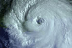 |
Better Prediction and Tracking
Today, two types of meteorological satellites—Geostationary Operational Environmental Satellites (GOES) and Polar Operational Environmental Satellites (POES)—measure moisture and temperature. But in 2011, National Polar-Orbiting Operational Environmental Satellites (NPOESS), scheduled to replace POES, will use ITT's Cross-track Infrared Sounder (CrIS) to track a vertical distribution of temperature, moisture, and pressure, which will aid both short- and long-term weather forecasting. ITT's GOES Advanced Baseline Imager, planned for launch around 2012, will add more spectral bands, faster imaging, higher spatial resolution, better navigation, and more accurate calibration. Additionally, ITT is developing concepts for the GOES-R Global Lightning Mapper and Hyperspectral Environmental Suite (HES): The Mapper will help detect and locate lightning and improve the routing of airlines around severe storms, while HES will help predict the path and strength of hurricanes and tornadoes. www.itt.com, www.thenewsmarket.com/ITT
Down here on Earth, a Tsunami Alert system, which includes 26 information analysis centers capable of receiving and distributing tsunami advisories, has been activated in Indian Ocean countries. The centers are linked to 25 seismological stations and three deep-sea sensors. www.sensorsmag.com/0806/SCtsunami1
But tsunami prediction needs help, because the inability of current methods to quickly determine a quake's "moment magnitude" (that is, its true size—which directly relates to its tsunami-generating potential) was a primary reason warning centers underestimated the quake that produced the 2004 Sumatra disaster.
Recently, scientists demonstrated that NASA-funded GPS technology can determine moment magnitude in just 15 minutes. "We'll always need seismology as the first level of alert for large earthquakes, and we'll need ocean buoys to actually sense the tsunami waves," says research leader Geoffrey Blewitt. But GPS adds the ability to quickly tell how much the ocean floor has moved. www.sensorsmag.com/0806/SCtsunami2
Now, Everyone Out!
Once imminent danger has been determined, Trichord Inc.'s Portable Evacuation Monitoring System (PEMS) aims to facilitate evacuation. Mobile PEMS carts equipped with wireless communication links, traffic sensors, video cameras, and solar-recharged batteries can collect and transmit traffic data even during Category 3 hurricanes, while Trichord's data management center and real-time monitoring applications are meant for use in operations centers or in field stations. The system provides real-time lane-by-lane speed, vehicle counts, travel time, and video imagery—all accessible within 60 s. The system promises to integrate and interoperate with existing transportation and emergency management systems.
PEMS can work between emergencies, too. The first major deployment began this summer in Hampton, VA, to assist during the final phases of Virginia DOT's Coliseum Central Highway Improvement Project. www.trichord-inc.com