

Technologies Help Prepare and Respond
Advance warning, leading to community preparedness and potential evacuation, is the best way to mitigate the effects of natural disasters," says Frank Koester, vice president and director of ITT Space Systems Div., Commercial and Space Science Programs. That's why his and other companies are working on new technologies for improved monitoring, prediction, and evacuation.
 |
Better Prediction and Tracking
Today, two types of meteorological satellites—Geostationary Operational Environmental Satellites (GOES) and Polar Operational Environmental Satellites (POES)—measure moisture and temperature. But in 2011, National Polar-Orbiting Operational Environmental Satellites (NPOESS), scheduled to replace POES, will use ITT's Cross-track Infrared Sounder (CrIS) to track a vertical distribution of temperature, moisture, and pressure, which will aid both short- and long-term weather forecasting. ITT's GOES Advanced Baseline Imager, planned for launch around 2012, will add more spectral bands, faster imaging, higher spatial resolution, better navigation, and more accurate calibration. Additionally, ITT is developing concepts for the GOES-R Global Lightning Mapper and Hyperspectral Environmental Suite (HES): The Mapper will help detect and locate lightning and improve the routing of airlines around severe storms, while HES will help predict the path and strength of hurricanes and tornadoes. www.itt.com, www.thenewsmarket.com/ITT
Down here on Earth, a Tsunami Alert system, which includes 26 information analysis centers capable of receiving and distributing tsunami advisories, has been activated in Indian Ocean countries. The centers are linked to 25 seismological stations and three deep-sea sensors. www.sensorsmag.com/0806/SCtsunami1
But tsunami prediction needs help, because the inability of current methods to quickly determine a quake's "moment magnitude" (that is, its true size—which directly relates to its tsunami-generating potential) was a primary reason warning centers underestimated the quake that produced the 2004 Sumatra disaster.
Recently, scientists demonstrated that NASA-funded GPS technology can determine moment magnitude in just 15 minutes. "We'll always need seismology as the first level of alert for large earthquakes, and we'll need ocean buoys to actually sense the tsunami waves," says research leader Geoffrey Blewitt. But GPS adds the ability to quickly tell how much the ocean floor has moved. www.sensorsmag.com/0806/SCtsunami2
Now, Everyone Out!
Once imminent danger has been determined, Trichord Inc.'s Portable Evacuation Monitoring System (PEMS) aims to facilitate evacuation. Mobile PEMS carts equipped with wireless communication links, traffic sensors, video cameras, and solar-recharged batteries can collect and transmit traffic data even during Category 3 hurricanes, while Trichord's data management center and real-time monitoring applications are meant for use in operations centers or in field stations. The system provides real-time lane-by-lane speed, vehicle counts, travel time, and video imagery—all accessible within 60 s. The system promises to integrate and interoperate with existing transportation and emergency management systems.
PEMS can work between emergencies, too. The first major deployment began this summer in Hampton, VA, to assist during the final phases of Virginia DOT's Coliseum Central Highway Improvement Project. www.trichord-inc.com
LBS Incorporates Sensors
Cell phone providers promote location-based services (LBS) as a way to send custom messages to subscribers based on their location—as reported by GPS or radiolocation and triangulation. Now LBSs are beginning to incorporate sensors.
Omnilink Systems Inc. claims it is the first to combine cellular, GPS, RFID, and sensor technologies to determine the status of mobile assets and people, and inform clients immediately if factors of interest (such as location, time, temperature, route, volume, and pressure) stray from predetermined ranges. Omnilink's Advanced Forward Link Trilateration (AFLT) technology works even inside buildings, buses, trains, and containers (cartons, pallets), the company says. Scalable software enables management by exception; alerts can be sent using a number of means (cell phone, email, etc).
The technology is being licensed and sold in markets such as the financial industry, health care, logistics, real estate and construction-site security, and transportation. But it has other interesting applications, too. For instance, a teenager carrying a cell phone who nears a sex offender's home could receive an alert, as could his or her parents. www.sensorsmag.com/0806/SClbs
Apple and Nike Instrument Workouts
Nike's new shoes incorporate sensors that communicate with Apple's iPod to display time, distance, and pace, as well as calories burned. Runners can review workout stats by run, or by week or month. www.apple.com/enews/2006/06/01enews1.html
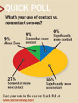 What s your use of contact vs. noncontact sensors? |
Sensors Expo Demos Linearization, Wireless Progress
Tau Research, the sensors business of Australian company Science Logic Pty Ltd., presented at Sensors Expo new technology that can allow sensor circuits to approach the theoretical limits of linearity performance. Science Logic CEO Carl Renneberg says sensor linearization is a hot area of research for his company, and one capable of delivering significant commercial benefit. The same technology can be used to optimize temperature compensation circuits, too: "We see this as a platform technology, with broad application in sensor systems," he explains. www.science-logic.net
From booth # 603 Tendril announced its deepened partnership with Ember Corp. Tendril, whose vision is to allow interaction with the physical world in areas where computing has previously been cost-prohibitive, offers the first distributed-system software that integrates different types of low-power sensors and actuators with enterprise and PC/PDA-based systems. The approach promises dramatic results, enabling OEMs to integrate wireless into their products in less than a week and allowing system integrators to deploy in just hours.
 |
Tendril and Ember will integrate Ember's ZigBee-compliant networking platform with other environments, including IP and building-automation networks, and PC/PDA-based applications. Tendril software will also be included in Ember packages such as the recently announced EM250 JumpStart and Development kits. www.tendrilinc.com www.ember.com
In a related announcement, Arch Rock Corp. says it has integrated the ZigBee stack with its open, hardware-independent software and systems suite to allow unprecedented flexibility and choice for product development. The company demonstrated ZigBee, integrated for the first time as a networking option over the IEEE 802.15.4 standard, with a TinyOS 2.0-based embedded operating system. Running on Ember's new EM260 chip, the integration creates a set of Arch Rock–enabled platform choices. "The significance of the integration of ZigBee and TinyOS 2.0 is profound for the wireless sensor industry and is in the true spirit of open systems," says Arch Rock president and CEO Roland Acra, who promises ease of deployment, operation, and enterprise integration as a result. www.archrock.com
Meanwhile, Helicomm demonstrated its integrated platform for wireless monitoring and location tracking. The system targets public safety, logistics, asset management, and healthcare applications. It consists of wireless mesh access points, low-power mobile tags, and an application management interface designed for quick integration and deployment. Thirty access points can cover a maximum 4 million sq ft area. The management-tool API promises seamless integration with third-party graphic and database tools. www.helicomm.com
Touchscreen Table
CNN reports that Mitsubishi's new DiamondTouch is a PC screen on a tabletop. People sit around it in specially equipped chairs and use their fingers to create and manipulate "objects" with the help of touch sensors embedded in the tabletop panel. Small electrical currents flow through the chairs and communicate with the panel, making clear whose fingers are making which changes.
www.sensorsmag.com/0806/SCtable
Tattletale Parking Meters
Cities such as New York and Baltimore have installed sonar-based parking meters that detect when a space is occupied and reset when a car moves out, says The Detroit News. The meters not only generate more income for the city but also allow payment with credit cards and cell phones. Networking them promises daily or weekly reports about parking and enforcement patterns.
www.sensorsmag.com/0806/SCparking