

Since 1983, the Instituto Geofísico (Institute of Geophysics of Ecuador) has been responsible for seismic and volcanic monitoring throughout the country. Its mission is to improve disaster preparedness and to lessen the impact of seismic and volcanic phenomena throughout Ecuador via constant monitoring, scientific research, and technology. Rather than responding to seismic events after they've happened—with the resultant loss of life and property—the intent is to adopt a more precautionary approach and to identify potential seismic events. Thanks to the Red Nacional de Sismógrafos (National Seismograph Network) and the Red de Observatorios Volcánicos (National Volcano Observatories), the institute is able to issue early warnings based on risk maps produced by scientists, allowing authorities and citizens to have enough time to take the appropriate precautionary measures. In the case of the eruptions of the Tungurahua volcano in July and August 2006, these early warnings reached hundreds of thousands of people, got them out of harm's way, and saved countless lives.
Monitoring Volcanoes Isn't Easy
The institute's monitoring network has been growing over the past 25 years partly to meet new needs, and mostly to take advantage of technological advances. International organizations have also donated equipment and trained personnel. However, this rapid progress presents new problems and challenges for which the institute has been trying to find solutions.
Volcanoes are monitored for vibration, gas emissions, lava spews, eruptions, deformations and/or any other unusual activity. Many types of sensors are used, but the most widely used are those that measure vibration. Others include IR sensors to measure gases and positioning devices that measure deformation. As magma rises towards the surface, volcanoes can emit greater quantities of gases, including sulphur dioxide, carbon dioxide, and water vapor. As the magma accumulates below the volcano's surface, the volcano's sides can bulge. Measuring ground deformation or changes to the surface of the volcano with deformation networks provides clues to activity that may be occurring below the surface and allows the volcanologist to better understand and/or warn of potential eruptions.
The primary challenge was to build a reliable, rugged, real-time telemetry network. Previous data collection equipment for seismic and volcanic monitoring collected only local data, requiring periodic visits to remote sites to retrieve them.
As recently as ten years ago, digital telemetry was used for applications involving periodic data transmission rather than continuous real-time data transmission, such as lahars (dangerous mudflows or landslides of volcanic debris) and deformation networks. Although the licensed band radios provided good results, they were subject to frequent interference and disconnects and the equipment was not robust enough for the climate conditions in which it needed to operate.
Implementing Rugged Telemetry Systems
The institute needed an affordable, real-time telemetry system that was both simple and sturdy. In 2002, an international organization installed FreeWave's DGR Series radios to transmit deformation data for the Cotopaxi volcano in the Andes and for a volcano in the Galápagos Islands. The radios produced very good results, reducing maintenance of monitoring stations to zero. More recently, one of the institute's engineers set up a photographic camera at the Reventador volcano for live monitoring and video of volcano activity, relaying the data via one of FreeWave's radios.
Currently, the institute has added FreeWave radios to many of its monitoring networks. Among the primary monitoring applications are real-time broadband seismic stations in the Imbabura and Tungurahua volcanoes, meteorological stations, stations that monitor volcanic gases, deformation stations using GPS technology and borehole sensors, remote digital cameras, with stations to quantify mud flow coming soon.
The Monitoring Networks in Action
Over the past six years, the FreeWave radios have proven their worth; connections at different distances have proven highly reliable and stable and the radios perform in extreme conditions, as evidenced by a radio that transmits images from the top of Cotopaxi, the highest active volcano in the world. The radio operates at temperatures below 0°C and at a height of 5947 m above sea level (Figures 1 and 2). The radios enable a variety of monitoring applications. Each piece of equipment is connected to the institute's internal network, allowing researchers to access it from any part of the network, without needing a specific PC or software (Figure 3). This makes processing data easier for the volcanologists.
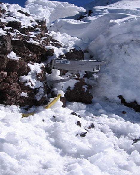 Figure 1. The camera in situ at the Cotopaxi volcano |
 Figure 2. The photos relayed from the summit of Cotopaxi (Click image for larger version) Figure 2. The photos relayed from the summit of Cotopaxi (Click image for larger version) |
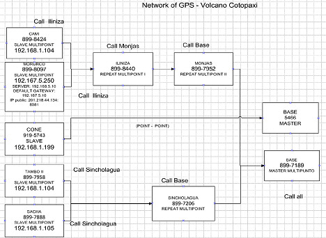 Figure 3. A diagram of the monitoring network (Click image for larger version) Figure 3. A diagram of the monitoring network (Click image for larger version) |
The radios have been used in conjunction with GPS receivers for deformation monitoring. Currently, the institute has a network with five GPS receivers on the Cotopaxi volcano. Soon, three more will be installed on the Tungurahua volcano. An example of a station can be seen in Figure 4. The monitoring systems' constant tracking of sites and deformations allows the institute to act as an early warning agency for the country. The institute has also used them for real-time monitoring of gases (Figures 5 and 6).
 Figure 4. A deformation monitoring station that includes a GPS, sensors, and communication equipment |
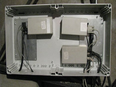 Figure 5. Volcanic gas monitor incorporating IR sensors to monitor gases as they escape from the volcano |
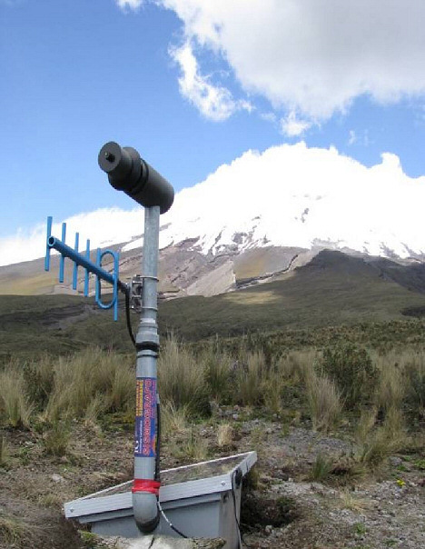 Figure 6. The exterior of a volcanic gas monitoring station, showing gas measuring sensors and communication equipment |
Seismic broadband monitoring using the radios enabled the institute to deliver early warning about the eruptions of the Tungurahua volcano in 2006 and in 2008, because the connected sensors allowed the researchers to see signs that other sensors did not. The data allowed the institute to predict the eruptions and to issue warnings, including the evacuation of highly dangerous areas around the volcano.
The engineers at the institute, because of the radios' performance and flexibility, continue to consider this transmission equipment as their best option for implementing the different applications and projects either underway or to be undertaken in the future, designed to safeguard lives and identify dangerous areas.