

Reflecting the emergent Internet of Things (IoT), billions of sensors collect and transmit data every second from devices connected to people and things both consumer and industrial throughout the world. Much of this IoT data has, or will have, location tags. Location-based data is a critical aspect of the sensor-driven data flood. Yet with this flood of sensor data come new challenges.
How will location-tagged sensor data be discovered, used and shared? How can a data-sharing infrastructure and its many applications support the rapidly changing sensors and their ever-increasing data volumes? Enter the Open Geospatial Consortium (OGC) Sensor Web Enablement (SWE) standards framework.
SWE standards provide a mature infrastructure allowing sharing of sensor resources in an openly defined manner, hiding underlying layers of complexity, the network communication details, and allowing heterogeneous sensor hardware to be accessed from any SWE-enabled application. A sensor network is composed of spatially distributed autonomous sensors to monitor physical or environmental conditions, such as temperature, sound, pressure etc. and to cooperatively pass their data through the network to applications.
A Sensor Web refers to Web-accessible sensor networks and archived sensor data that can be discovered and accessed using standard protocols and service interfaces. Since 2001, the OGC has been engaged in developing, testing and promoting the use of standards for Web-enabling sensors and sensor observations. SWE standardizes Web service interfaces and data encodings that can be used as building blocks for a Sensor Web. SWE incorporates models for describing sensor resources and sensor observations (see figure 1).
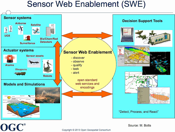
Fig. 1: SWE Overview
Further, it defines Web service interfaces leveraging the models and encodings to allow accessing sensor data, tasking of sensors, and alerting based on gathered sensor observations. The standards are encoding and interface specifications for use by software developers; SWE uses XML and robust Web service standards. Importantly, robust software components exist for supporting development of SWE implementations.
Specifically, the SWE standards baseline offers the following functionalities:
- Description of sensor data to enable further processing.
- Description of sensor metadata including properties and behavior of sensors, as well as correlating reliability and accuracy of collected measurements.
- Description of sensor processes so that users and applications have information about how an observation was generated.
- Discovery of and access to observations and sensor metadata based on standardized data formats and appropriate query and filter mechanisms.
- Tasking of sensors for the acquisition of measurement data.
SWE is the only open, international standards suite that provides a comprehensive platform for publishing, discovering, assessing, accessing and using sensors and sensor systems of all kinds. The SWE standards are open, with the standards documents freely available on the OGC website. Also, the consensus process in which SWE standards are created and maintained is open to all who want to participate, and the process guards against future intellectual property claims that would compromise the standards' openness.
Because all sensors have a location and location is often important, the SWE standards have been developed and will continue to be enhanced by the principal international industry standards development organization focused on geospatial standards, the OGC. Other important SWE attributes include:
- Fundamental, widely used, and open Internet/Web standards as well as best practices in software programming are the basis for SWE encodings and interfaces.
- Use requires no proprietary platform support, and yet organizations can implement the SWE standards on platforms other than the open Internet/Web.
- One can implement SWE in secure and closed networks.
Importance of SWE standards
Open sensor standards enable applications to access and use sensor observations from any sensor. Further, using standard interfaces and descriptions allow applications to integrate and use new sensors and sensor networks as they become available.
The SWE framework provides significant benefits for supporting the integration and fusion of a wide variety of assets, and readily enables a system that is able to sense and react to threats or opportunities. One overriding requirement is to enable the straightforward ability to integrate diverse sensors into an integrated system.
Prior to the availability of SWE, most application developers integrated sensor resources into observation systems and applications through proprietary mechanisms. This manual bridging between sensor resources and applications leads to extensive and ongoing adaption efforts. Integration costs escalate, limiting the size and value of sensor webs and the value of sensors and sensor web applications.
SWE provides a coherent standards infrastructure to treat sensors in an interoperable, platform-independent and uniform way. As illustrated in figure 2, the Sensor Web Layer of open encoding standards and application programming interfaces (APIs) hides the heterogeneous sensor hardware and communication protocols from the applications. SWE facilitates the integration of various sensors by providing a unified and vendor-independent interface.
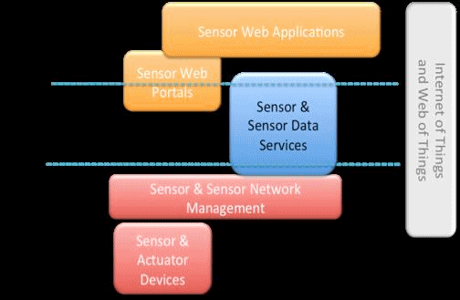
Fig. 2: OGC's SWE Framework
Because the geospatial elements of SWE are based on the OGC's well-established suite of geospatial standards, SWE enables the integration of near-real-time data into spatial data infrastructures and GIS systems.
SWE Maturity Report
The OGC SWE Implementation Maturity Engineering Report is a documented assessment of the maturity of implementations of SWE standards. The different examples of listed projects within this document clearly show that the SWE standards help to realize various kinds of applications. In particular, they are instrumental for flexibly integrating various kinds of sensors and sensor data. The examples show the wide range of sensor information that can be provided via SWE services, from in-situ sensors (e.g. water gauges, weather stations) to mobile sensors (e.g., tracked firemen, air quality sensors on busses, as well as UAVs), to remote sensors (satellites).
SWE standards are implemented in hundreds of applications ranging from mobile to enterprise, and in domains including disaster management, remote sensing, environmental monitoring, transportation management, defense, security, public safety, meteorology, hydrology, alerting, and building monitoring systems. Implementations include:
- The United States Government (USG) Department of Defense (DoD) / Intelligence Community (IC)
- NASA SensorWeb (see figure 3)
- US National Ocean and Atmospheric Administration (NOAA) Integrated Oceans Observing System (IOOSIOOS)
- European Space Agency (ESA) SPS satellite tasking
- European Sensor Web Infrastructure Management (SWIMA) – monitoring water quality in river catchments
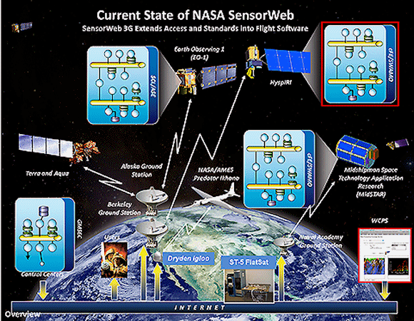
Fig. 3: NASA SensorWeb
Part of the future of SWE is the OGC Sensor Web for IoT, which will enable many IoT applications based on sensors. The goal of the new Sensor Web for IoT Standards Working Group is to develop one or more lightweight standards based on existing "Web of Things" protocols while also leveraging the existing and proven OGC SWE standards. The initial scope is to make observations captured by IoT devices easily available to applications and users through data aggregation portals.
OGC SWE Certification
OGC certification of products that implement SWE standards is beneficial to vendors and end users. Vendors who have had their products pass the OGC compliance tests and who have obtained an OGC Trademark License may advertise their products as OGC Compliant. Users can be assured that such products implement particular standards correctly.
The purpose of the OGC Compliance Program is to increase system interoperability while reducing technology risks. Vendors gain confidence that they are providing a product compliant with OGC standards, which will be easier to integrate and easier to market. Buyers gain confidence that a compliant product will work with another compliant product based on the same OGC standard, regardless of which company developed the product.
The OGC Compliance Program provides a free online testing facility, a process for certification of compliant products, and coordination of a vibrant community of developers.
OGC SWE compliance certification steps are:
-
Vendors tests candidate product against test suite(s) online
-
a. Sensor Observation Service (SOS) versions 1.0.0 and 2.0
b. Sensor Planning Service (SPS) versions 1.0 and 2.0 - After the product passes test, vendor submits test results to OGC Compliance Team
- OGC Compliance Team evaluates test results and approves or denies
- OGC Denial – vendor fixes candidate product and retests
- OGC Approval – vendor and OGC resolve a trademark licensing agreement and fees
- OGC issues compliance certificate to vendor
Conclusion
The explosion of sensors in what we are calling the Internet of Things will only reach its potential value for sensor technology providers and users when sensors and sensor data are easily published, discovered, assessed, tasked and used in applications. Also, with the rapid evolution of sensors, users want to be able to swap out and add new technologies. Mature standards with proven implementations are the best path to lower costs and higher efficiencies in a sensor ecosystem.
About the Author
Denise McKenzie is the Executive Director, Communications and Outreach for the not-for-profit standards organization Open Geospatial Consortium (OGC). She is responsible for the planning and execution of marketing, communications and education programs to raise awareness and increase application of open geospatial and location standards by technology providers and users worldwide. Her other international roles include representation for the OGC at the United Nations Global Geographic Information Management (UNGGIM) committee and Chair of the Marketing and Outreach committee for the Global Spatial Data Infrastructure (GSDI) association. Prior to her role with OGC, Denise worked for over 12 years with the Victorian Government, Australia in areas of strategic policy, collaboration. and innovation.
Related Stories
Internet of Nano Things (IoNT) Market Worth $9.69 Billion by 2020
EBV Elektronik and IP500 Alliance announce partnership
ZigBee Remote Control 2.0: Updated Standard for Radio Frequency-Based Remote Controls
Sensorstream Aims To Put a Computer on Every Wrist
Broadcom Announces WICED Sense to Grow Internet of Things Applications